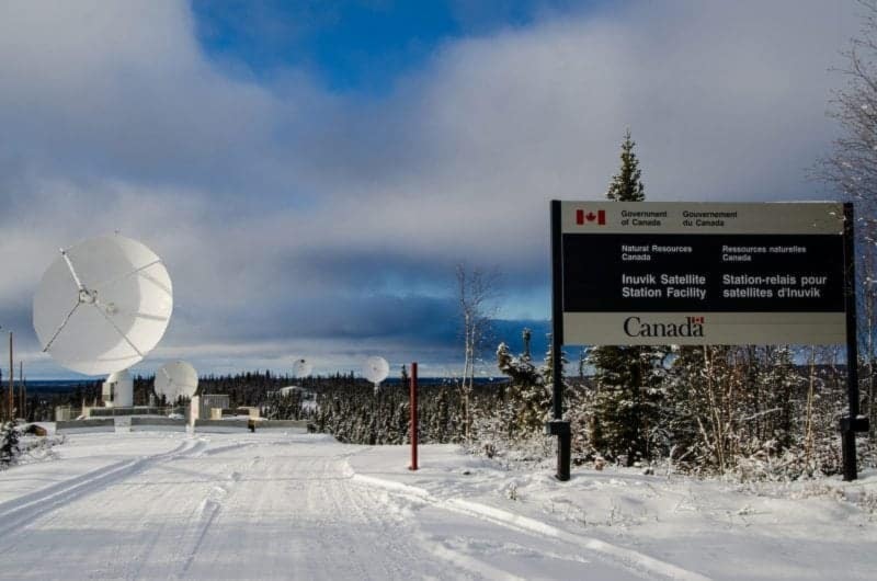
Anyone driving from the airport into town will see a number of satellite stations next to the Dempster Highway.
Quietly, that location is a small international hub of information, with satellite operations being performed by Canada, Germany, Sweden and France.
Next week, 30 scientists and ground station specialists from 30 countries will meet in Inuvik to discuss the Landsat program, run by the United States Geological Survey. It will be the 26th session of the Landsat Technical Working Group, which meets annually.
The program, which began in 1972, was borne out of NASA and the United StatesSA����Ӱ�Ӵ�ý� space program. Landsat has launched eight satellites, the most recent in 2013 and the next planned for 2020, to photograph the Earth and how it is changing.
The program has collected millions of images to help people map changes on the planetSA����Ӱ�Ӵ�ý�s surface over time.
Each year, the Landsat group, who are the people operating reception stations for the data, meet to discuss issues regarding the collection of data, developments in technology, the health of their stations, what the data could be used for, how to archive it and more.
SA����Ӱ�Ӵ�ý�ItSA����Ӱ�Ӵ�ý�s an operational meeting,SA����Ӱ�Ӵ�ý� explained Corrina Vester, manager of stakeholder relations for the Canadian Centre for Mapping and Earth Observation.
The information is used for any number of purposes.
SA����Ӱ�Ӵ�ý�ItSA����Ӱ�Ӵ�ý�s really used to monitor the planet, so it can detect and measure the changes in land cover and land use,SA����Ӱ�Ӵ�ý� said Vester. SA����Ӱ�Ӵ�ý�For instance, as land moves from being primarily agricultural to a city, it can measure that.SA����Ӱ�Ӵ�ý�
It can detect the extent of burning after forest fires, environmental changes, desertification and much more, all pixel-by-pixel and mapped over long periods of time.
Inuvik makes an ideal satellite location because of its proximity to the North Pole. Vester gave a metaphor of winding wool around a ball, explaining that the northern and southern poles of the ball offer more occasions to capture the satellite signal.
SA����Ӱ�Ӵ�ý�You have a higher frequency of downloads in far northern or far southern locations,SA����Ӱ�Ӵ�ý� she said. SA����Ӱ�Ӵ�ý�Inuvik is in a perfect location.SA����Ӱ�Ӵ�ý�
The Mackenzie Valley Fibre Link means large data loads can be sent into the global network.
Vester sees the satellite operations in Inuvik as a growing industry. SA����Ӱ�Ӵ�ý�Our forecasts say yes,SA����Ӱ�Ӵ�ý� she said.
The conference will take place June 5 to 9 and include a technology workshop for students in Aurora CollegeSA����Ӱ�Ӵ�ý�s Environment and Natural Resources Technology Program.


