The month of November proved to be an average one for Yellowknife's historical trends in temperature and precipitation according to the federal department of Environment and Climate Change Canada.
The medium temperature over the month was -13.3 C, the 37th warmest in 77 years of data. This proved to be only slightly warmer than the average for that period which was -13.7 C, said Brian Proctor, meteorologist with the department.

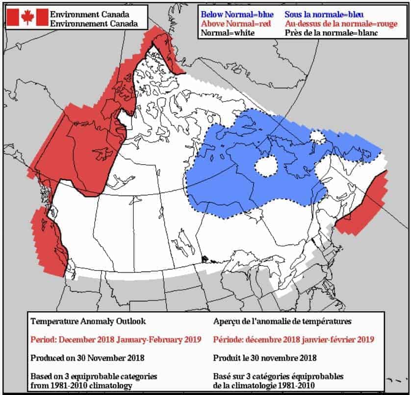
The temperature deterministic forecast for the next three months show that temperatures will be warmer than average in the western part of the NWT. In the North Slave and Yellowknife region, temperatures are expected to be normal on average.
SA����Ӱ�Ӵ�ý�So we were four-tenths of a degree warmer than (the average) over the period record, and slightly warmer than normal,SA����Ӱ�Ӵ�ý� he said.
Last year at this time, the temperature was -16.3 C, three degrees colder than in 2018.
Proctor said the warmer than average temperature entering the main winter months is a key factor to watch as this typically means higher levels of precipitation. With enough precipitation build-up leading to the early spring, it will mean wetter conditions that help prevent forest fires.
SA����Ӱ�Ӵ�ý�We really need the late winter snow falls because it can make a tremendous difference, especially with the early season forest fires,SA����Ӱ�Ӵ�ý� he said.
Precipitation was slightly drier than average, as the department measured 23 mm of snow and rain over the 30 days. This proved to be less than the 25.1 mm average.
SA����Ӱ�Ӵ�ý�It was a little bit drier but not a sharp deviation,SA����Ӱ�Ӵ�ý� he said. SA����Ӱ�Ӵ�ý�The closer we got into the Mackenzie Mountains, the drier it was really getting.SA����Ӱ�Ӵ�ý�
Last year at this time, there was 15.8 mm, which was much drier, Proctor said., almost certainly because of the warmer temperature.
SA����Ӱ�Ӵ�ý�The warmer it is, the easier it is to carry more moisture,SA����Ӱ�Ӵ�ý� he said.
The less than cooler temperatures in 2018 has also meant slightly slower ice development, Proctor said.
SA����Ӱ�Ӵ�ý�From what we have seen, it has been a little slower for the ice setting up on Great Slave,SA����Ӱ�Ӵ�ý� he said.
There is still quite a bit of open water toward the centre of the lake in some of the Northern Arms. In general ice is starting to form fairly rapidly. It might have slowed down a little bit in terms of ice development, but it is progressing fairly rapidly now.SA����Ӱ�Ӵ�ý�
Based on the temperature deterministic forecast for the next three months (December to February), Proctor said much of the NWT will be split with the western region set to be warmer than normal, while the North Slave and Yellowknife area to the east will have normal temperatures. He said that right now models are showing lower precipitation to the west, but he said may not end up being the case.
SA����Ӱ�Ӵ�ý�It is showing that it will be a little bit drier, but I would be a bit leery of that signal because if it is warmer than normal, then we would typically see a little bit more precipitation,SA����Ӱ�Ӵ�ý� he said, adding this should be expected for the predicted El Nino winter SA����Ӱ�Ӵ�ý� when the warming of the Pacific Ocean surface waters lead to a shift in atmospheric circulation and changes to weather patterns across much of the planet.
SA����Ӱ�Ӵ�ý�This is fairly common with El Nino, as well. Often times it diverts the storm track up into the Yukon and across the Mackenzie Valley as well, as opposed to coming across British Columbia.SA����Ӱ�Ӵ�ý�
Shaun Morris, president of the Great Slave Snowmobiling Association said this season is one of the warmest of the 27 years he has been in Yellowknife.
SA����Ӱ�Ӵ�ý�For us the weather seems a bit warm and it is odd considering it is December,SA����Ӱ�Ӵ�ý� he said. SA����Ӱ�Ӵ�ý�I haven't looked at the historical stats, but it sure feels warmer than it has any other year.SA����Ӱ�Ӵ�ý�
Morris said snow levels are very low for sledding, pointing out that Frame Lake has no snow for trail-walking, despite the ice being at about 11.5 inches (29.21 cm) on most locations tested on the water body.
SA����Ӱ�Ӵ�ý�I think this year we had that one big dump of snow (at the end of October) that everybody expected to get us ready for snowmobiling early, By the second week of November we had a big dump again, but it hasn't translated to much snow in the bush or on the lakes. It has kind of just blown away.SA����Ӱ�Ӵ�ý�


