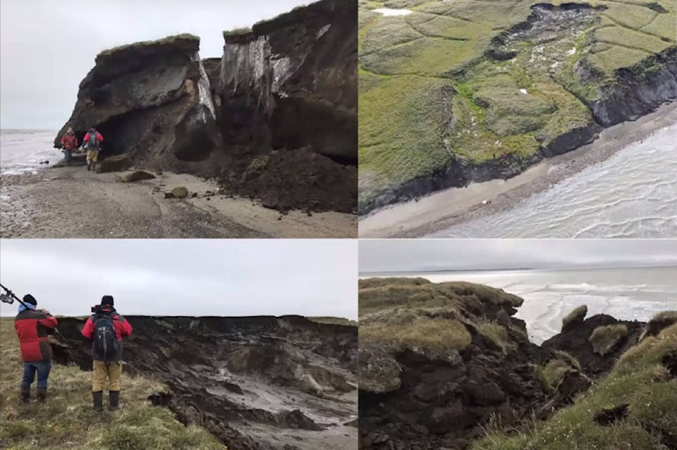
Vegetation mats could be used to slow the rate of permafrost thaw in the Beaufort Delta, which is eroding into the ocean at an alarming rate.
ThatSA����Ӱ�Ӵ�ý�s the latest findings from the work of Aurora Research Institute scientists Erika Hille and Celtie Ferguson, who presented the latest information on the Beaufort Sea coastal restoration project in the latest Aurora Research Institute speaker series, which was first presented Feb. 1 and was published online Feb. 28.
SA����Ӱ�Ӵ�ý�We hear a lot about how arctic coastlines are rapidly eroding,SA����Ӱ�Ӵ�ý� said principal investigator Hille. SA����Ӱ�Ӵ�ý�However, itSA����Ӱ�Ӵ�ý�s important to realize that the rate of erosion varies with both space and time. Some areas are more vulnerable to erosion than others and for most of the arctic the rate of erosion is increasing.SA����Ӱ�Ӵ�ý�
From 1980 to the year 2000, the entire coastline of the Beaufort Sea eroded at an average of 1.1 metre per year. But, Hille added, there were areas that eroded up to 10 metres per year SA����Ӱ�Ӵ�ý� notably around the Mackenzie Delta region.
Air temperature data collected between 1948 and 2016 show the Arctic, particularly the Beaufort and Mackenzie Delta regions, are warming way faster than the global average.
SA����Ӱ�Ӵ�ý�The western Canadian Arctic in particular is experiencing climate change at a more pronounced rate than the eastern Canadian Arctic,SA����Ӱ�Ӵ�ý� said Hille. SA����Ӱ�Ӵ�ý�Climatic changes that weSA����Ӱ�Ӵ�ý�re observing in the Arctic are influencing other key environmental factors and accelerating the rates of erosion.SA����Ӱ�Ӵ�ý�
Many factors
One major factor for the high rate of coastal erosion is the fact much of the western Arctic is sitting on a layer of permafrost, which normally remains frozen all year round. But because of the warmer air, the permafrost has been thawing, creating an open underneath soil, which then collapses into it.
Permafrost would be protected by other factors, such as vegetation, soil and sea ice, but in the latterSA����Ӱ�Ӵ�ý�s case warmer temperatures are leading longer ice-free periods in the summer. This leaves the coastline exposed to waves its not built to deal with for longer periods each year.
A third factor accelerating the regions return to the sea is the generous supply of lakes in the region SA����Ӱ�Ӵ�ý� well into the 10s of thousands.
SA����Ӱ�Ӵ�ý�During our mapping work we observed locations where coastal erosion led to the catastrophic drainage of coastal lakes,SA����Ӱ�Ӵ�ý� said Hille. SA����Ӱ�Ӵ�ý�So coastal erosion is leading to unprecedented changes to the landscape. This is impacting communities infrastructure as well as ancestral sites.SA����Ӱ�Ӵ�ý�
With all the soil getting displaced, researchers wondered how it was affecting the water column. Thanks to a $423-thousand grant, they were able to map out the affected area to compare with historical data and study the water quality.
A second goal of the four-year study, which wraps up this year, is to test if vegetation can be used to protect permafrost and slow down the speed it erodes.
SA����Ӱ�Ӵ�ý�WeSA����Ӱ�Ӵ�ý�re able to capture small details such as the vegetation plots,SA����Ӱ�Ӵ�ý� said GIS technician and drone pilot Ferguson. SA����Ӱ�Ӵ�ý� We can also do head wall and cliff edge surveys. We can capture oblique or angled photos of the landscape. Or of the entire site in one picture, as well as just documenting the fieldwork process, which is always fantastic to have.SA����Ӱ�Ӵ�ý�
Tough roots
A series of tests were conducted to determine if vegetation could be used to protect permafrost or even reduce degradation.
Vegetation is seen as an ideal solution because itSA����Ӱ�Ӵ�ý�s biodegradable, can hold soil in place and serves as a natural insulator.
To test if it would work, several plots of sod were transplanted to exposed permafrost layer and allowed to take root again and a temperature sensor was buried in the soil. Three plots in undisturbed were established as a control, three more used in an active thaw slump as a second control and then the test area made up the last three.
SA����Ӱ�Ӵ�ý�What we found was that although the temperature underneath the transplanted vegetation Mat did increase to about zero degrees Celsius SA����Ӱ�Ӵ�ý� meaning that there is no permafrost underneath SA����Ӱ�Ӵ�ý� it is still cooler than the disturbed plot,SA����Ӱ�Ӵ�ý� said Hille. SA����Ӱ�Ӵ�ý�Which suggests that we can use vegetation mats to cool down permafrost or cool down the ground.
SA����Ӱ�Ӵ�ý�The undisturbed terrain remained below zero degrees Celsius year round. The disturbed terrain was notably warmer than the undisturbed terrain.SA����Ӱ�Ӵ�ý�
While a possible solution, Hille cautioned there were important factors to keep in mind with using vegetable mats, such as ensuring theySA����Ӱ�Ӵ�ý�re using local flora to not accidentally introduce invasive species, and the cost of transplanting a vegetation mat are expensive so finding a way to mass produce them would also be helpful.
Regardless, the use of natural, organic materials the biosphere is already equipped to deal with is favourable to manufacturing new chemicals to do the same thing, said Hille.
SA����Ӱ�Ӵ�ý�I would caution against using man-made materials because as I mentioned earlier if it doesnSA����Ӱ�Ӵ�ý�t work and it ends up breaking or eroding into the sea then you could have a risk of pollution.SA����Ӱ�Ӵ�ý�
Muddy waters
There is an lot of material locked up in permafrost, from the more well documented methane deposits keeping climate scientists awake at night to buried artifacts from bygone eras. But in-between each of those is a lot of soil, which is being carried into the Arctic ocean by rivers as the permafrost thaws.
Hille noted researchers were keeping an eye on three major products of erosion SA����Ӱ�Ӵ�ý� fine materials like organic sediments, major ions which could react with other materials and potential contaminants like mercury, noting those three were being documented in permafrost slumps upriver in the Peel River region.
So far, theySA����Ӱ�Ӵ�ý�re finding much of the same, but with a few additional surprises. Hille said water samples collected showed some traces of metals like barium, iron and manganese.
SA����Ӱ�Ӵ�ý�In the absence of industrial and mining activities in the area this is likely derived from permafrost thaw,SA����Ӱ�Ӵ�ý� she said. SA����Ӱ�Ӵ�ý� What we found was as we expected was the water quality of Kugmallit Bay was related to distance from the Mackenzie river outlet. We saw that the concentration of sediment organic carbon, major ions and trace metals decreased with distance from the Mackenzie river.SA����Ӱ�Ӵ�ý�
Material locked away in the many coastal lakes could also affect water quality in the Arctic Ocean, as they can drain into the ocean when eroded enough.
From photo to digital model
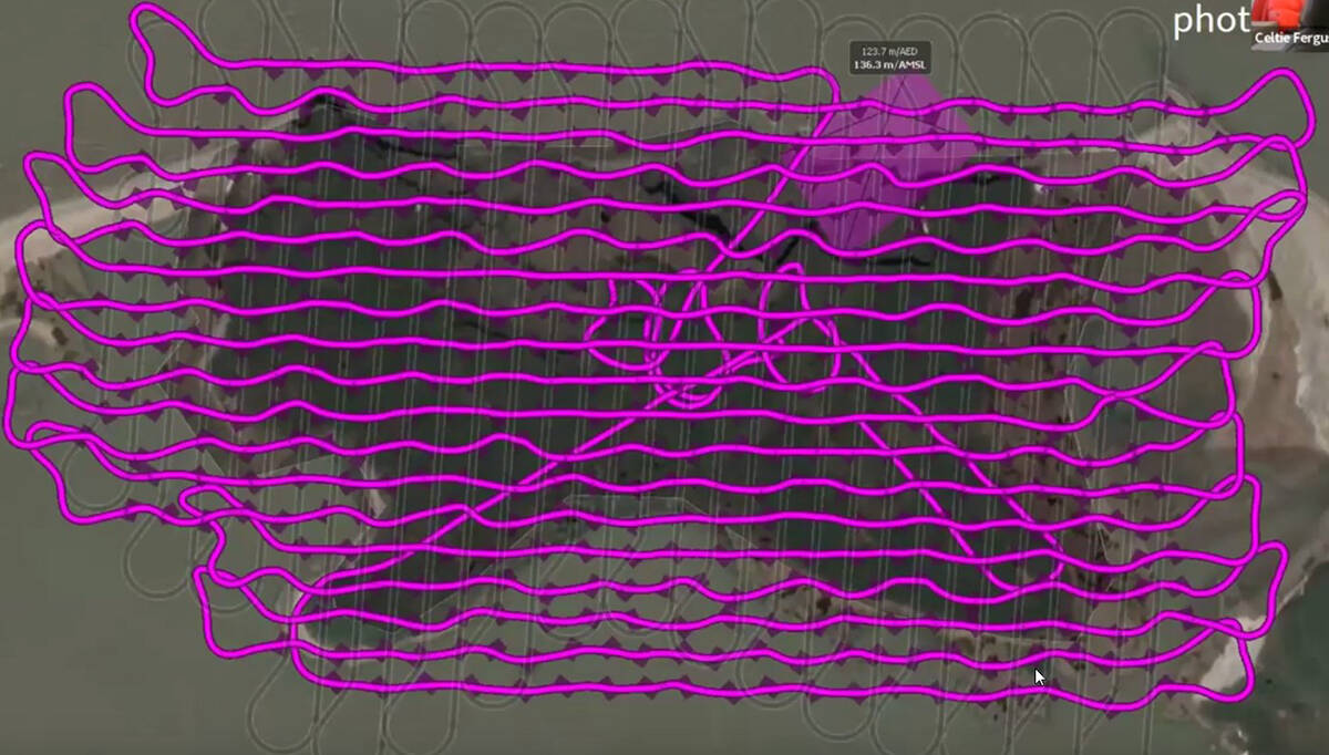
Ferguson said her work in the project involved several different applications of aerial drones, which include traditional aerial photography but also by using a technique called photogrammetry to re-create study areas digitally in 3D.
Currently, the ARI is using two different types of drones in its work SA����Ӱ�Ӵ�ý� a fixed wing and a quad-copter. Each has specific uses in the field, with the quad-copter able to take photos and videos in hard-to-reach places and the fixed wing aircraft mapping from far further above.
Using images taken from hundreds of angles by the fixed wing drone, Ferguson said she was able to recreate an area as a digital 3D object.
SA����Ӱ�Ӵ�ý�(Because) the photos overlap each other weSA����Ӱ�Ӵ�ý�re able to then process the photos into 3d models,SA����Ӱ�Ӵ�ý� said Ferguson. SA����Ӱ�Ӵ�ý�It does that by extracting points that are shown in multiple pictures and it builds the 3d model in space.SA����Ӱ�Ӵ�ý�
Once researchers had up-to-date images of the landscape theySA����Ӱ�Ӵ�ý�re surveying, theySA����Ӱ�Ӵ�ý�re able to compare it to historical maps to see whatSA����Ӱ�Ӵ�ý�s changed over time.
Comparing the current coastline to historic maps, Ferguson was able to create a map showing just how much coastline has disappeared since 1967.
SA����Ӱ�Ӵ�ý�WeSA����Ӱ�Ӵ�ý�re seeing up to 100 meters of erosion,SA����Ӱ�Ӵ�ý� she said. SA����Ӱ�Ӵ�ý�Whereas weSA����Ӱ�Ӵ�ý�re also seeing some areas where thereSA����Ӱ�Ӵ�ý�s been only up to 20 meters of erosion.
SA����Ӱ�Ӵ�ý�WeSA����Ӱ�Ӵ�ý�ve also got Tuk island. Taking a look at the net change weSA����Ӱ�Ӵ�ý�re seeing kind of an average of 80 to 120 meters.SA����Ӱ�Ӵ�ý�
Check out the map .
Check out the model .